A model for landslides involving water and rock
Extreme natural phenomena are becoming more frequent, and at the same time our planet is becoming more and more densely populated. This increases the risk of disasters and the need to prevent them. Therefore it is important to set up dams, avalanche barriers and other protective measures in the right places. While computer programmes have been used for many years to simulate landslides, they represent moving material in debris flows or avalanches in a very simplistic way. This can be a problem as the geographer Martin Mergili from the University of Natural Resources and Life Sciences in Vienna (BOKU) explains. Models which are too simple often fail to reflect the complex reality. In a project funded by the Austrian Science Fund FWF, a research group led by Mergili has now developed a simulation environment that is intended to provide a more realistic picture of flowing material.
Complex processes
Debris flows or avalanches are generally difficult to simulate, explains Mergili: “These phenomena involve complex physical processes. They contain material of different grain sizes - from very fine mud to large pieces of rock - plus water, and, in extreme cases, ice and snow. That means there are many materials that interact, and this mixture moves down the slope.” He goes on to explain that there are some models on the market for modelling processes from avalanches to debris flows and rockfalls, but “most of them use a so-called single-phase model. The water and the rubble is all aggregated and calculated as a homogeneous mass.” Mergili explains that this is inadequate for simulating many natural events and quotes the example of the Bondo landslide in Switzerland a year ago: several million cubic metres of rock mass started to slip and eventually ended up as a huge mudslide, devastating the whole place. Rock and water coincided in this instance, and this is too complex for previous calculation methods.
Liquid and solid components in debris flows
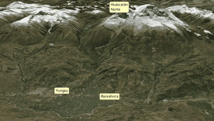
Another particularly complex incident took place in Peru, in the Santa Cruz valley of the Cordillera Blanca mountain range. A slope slid into a lake and triggered a tidal wave. “The lake overflowed and the tidal wave reached a lower-lying lake”, explains Mergili. “The lake below overflowed as well and eroded a great deal of loose material. The result was a mudflow with great amounts of water and loose material, which moved a few kilometres downhill until it reached a third lake, where it came to a standstill.” According to Mergili, previous single-phase models would not be sufficient for such phenomena. “It’s exactly for processes of that level of complexity that you require a two-phase model so that water and debris can be considered separately”, explains the researcher. Such a model was developed in the context of international cooperation between a number of German and Austrian universities and research institutes, including the BOKU under the leadership of Martin Mergili. While the physical principles were developed in Germany, Mergili’s group was responsible for the integration of real terrain data. The Austrian part of the joint project was financed by the FWF.
Good match with real-life natural events
To evaluate the new model, the researchers made calculations based on events such as the one in Santa Cruz. Mergili was satisfied that the sequence of events of the Santa Cruz process chain could be well reproduced with the new tools. “It turned out, however, that it is not easy to calibrate and optimise the parameters in such a way that the model can be used for predictive purposes.” To be able to make predictions, the researchers would have to compute as many well-documented events as possible. The data for the simulations is provided by a geographical information system, or “GIS” for short, which basically consists of electronic maps representing e.g. terrain data. Austria, for example, has been mapped in three dimensions to the nearest square metre. The new simulation environment, called “r.avaflow”, is integrated directly into such a GIS. Another special feature of the system is the fact that the simulation environment is open source. “It is freely available, and certain test data are also available for download. People are free to use them at their own risk”, says Mergili. Currently r.avaflow is being tested and adapted internationally.
Model already in use
The transition into practice was quicker than expected, reports Mergili: “The model is being used more than I would like to see at the moment. It is already being used for practical applications, but I would be happier if it were to be tested a little longer.” The scientist would like to get more feedback on possible weaknesses and more precise parameter sets before seeing it used in real life. “In Switzerland, for example, the new model is already being used for actual risk assessments”, notes the researcher.
Personal details Martin Mergili is a geomorphologist at the University of Natural Resources and Life Sciences, Vienna (BOKU) and the University of Vienna. He is interested in the development of simulation tools for landslides, regional and national hazard analysis, as well as environmental changes in high mountains and the associated risks.
Publications
